
How will fire shape the future of the Iberian Peninsula?
August 2025 was marked by smoke and extreme heat, with countries like Spain and Portugal facing record-breaking wildfires. The latest climate simulations from I4C highlight the escalating fire risk in the Iberian Peninsula and its far-reaching impact.
In 2025, the Iberian Peninsula has experienced unprecedented wildfires: a persistent, underlying signature of climate change. Extreme events involving increasing temperatures and longer dry periods are expected to become more frequent and severe, making proactive planning essential.
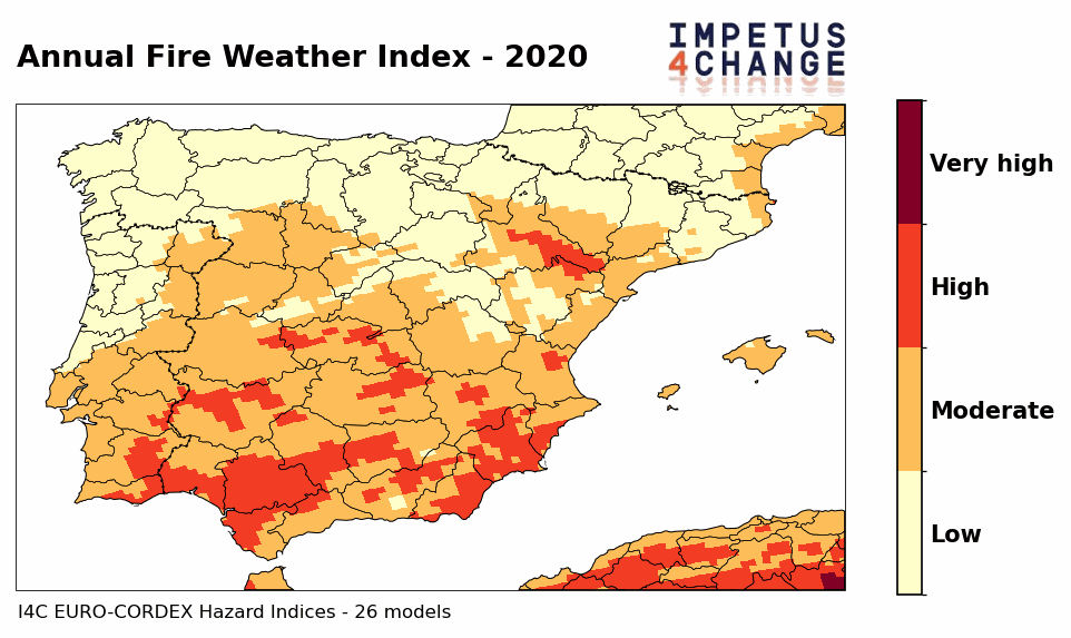
Our climate scientists recently performed a multi-model simulation of fire risks in the Iberian Peninsula. This analysis is encapsulated in the GIF animation below:
The GIF illustrates FWI projections over the Iberian Peninsula from 2020 to 2100, based on multi-model EURO-CORDEX simulations included in the I4C hazard indicator suite.
Working with city experts, I4C is co-developing tailored climate services, including hazard and risk assessments, to guide effective adaptation planning. The model simulation above is based on I4C hazard indicators. These indicators are part of a broader suite of climate hazard indices that I4C is developing to support local and regional decision-makers to minimise the impact of climate change on both communities and ecosystems.
Read the rest of the article to understand the ‘impetus’ behind this data visualisation and discover how the following insights can support adaptation strategies across the Iberian Peninsula — and beyond.
What do our modelling simulations show?
I4C models present projections of fire risk (the Fire Weather Index[1]) across the Iberian Peninsula from 2020 to 2100, using EURO-CORDEX climate model simulations. It shows a robust increase in fire risk throughout the century.
High-risk conditions, initially concentrated in southern and eastern areas, progressively spread northward. By the end of the century, half of the Iberian Peninsula is projected to face high fire risk, with most regions experiencing moderate risk year-round.
[1] The Canadian Fire Weather Index (FWI) is a tool that helps anticipate wildfire danger levels. It combines information on temperature, humidity, wind, and rainfall to estimate how dry vegetation is and how fires could behave under current conditions. By converting weather data into fire danger levels, the FWI gives authorities a clear picture of when and where fire risks are highest.
Why the focus on Spain and the Iberian Peninsula?
In August 2025, wildfires burnt more than 400,000 hectares in Spain, accounting for two-thirds of the total burned area in Europe in 2025 (Copernicus EFFIS). The Mediterranean region is a well-known climate change hotspot, facing more frequent and intense heatwaves, droughts, and wildfires. Already this summer, the sea surface temperature anomaly reached +3.7°C above average, creating extreme conditions conducive to fires.
Furthermore, Barcelona has been involved in I4C as 1 of 4 ‘Demonstrator Cities’. Working directly with cities like Barcelona provides a lens for the I4C project to bridge science and local-level policy in real-time and in response to cities’ actual climate adaptation needs. This fits with the project’s ultimate objective, to improve the quality, accessibility, and usability of near-term climate information and services, supporting adaptation from local to regional scales.
Why is this analysis (the I4C climate hazard indicators) unique or especially relevant for cities developing urban climate adaptation plans?
The I4C indicators are developed together with local stakeholders — city authorities, planners, and communities — so the information meets real-world needs. Having been built using advanced and robust climate models, the indicators turn complex data into clear, practical insights. Ultimately, precise climate information allows cities and communities to anticipate hazards and implement measures that reduce impacts on both the environment and populations.
Furthermore, the I4C indicators can be used to foster collaboration between scientists and city authorities, bridging the gap between raw climate data and practical, locally tailored knowledge.
Looking beyond the Iberian Peninsula: Where do we go from here?
I4C is developing higher-resolution projections tailored to urban and regional planning, helping cities like Barcelona design targeted adaptation strategies. The project is also creating seamless climate predictions that integrate different modelling approaches, supporting decision-making across multiple timescales — from seasonal outlooks to long-term planning.
By providing locally relevant data and insights, I4C supports local authorities in co-developing and implementing bottom-up adaptation policies that strengthen urban resilience in the face of increasing climate risks.
Stay tuned for more project updates and insights!