
Newcastle upon Tyne is situated in the northeast of England, on the northern bank of the River Tyne. Originally a Roman outpost at the edge of the Roman Empire on Hadrian’s Wall, it became the main crossing point over the river between London and Edinburgh.
The Tyneside region is known for its innovative and hard-working people and saw most of its growth during the Industrial Revolution. During this time, coal mining and shipbuilding were the main industries where locals like Joseph Swan, Lord Armstrong, and George Stephenson pioneered electricity, hydroelectricity, and the railways, respectively.
The city currently has a population of 300,000, with the Tyneside area being around 800,000. The city centre itself is compact on a steep hill between the River Tyne to the south and the Town Moors to the north and west. As the city has grown, there have been strict constraints on development through the protection of the historic Town Moors, creating a unique, large green space within easy reach of the city centre.
Climate challenges the city is facing:
Surface Water flooding
In the summer of 2012, flooding events impacted the City in a way that has not been seen in our lifetime. The heavier rainfall we experienced is a direct result of climate change, and such events will become more frequent, likely to cause more disruption and damage in the future.
Urban areas, like the city centre, are more vulnerable to surface water, due to the amount hard hard-standing areas. The topography of the city increases the risk too.
Several historical watercourses were covered over as the city grew, and water is now managed through engineered highway drainage and sewer networks. These do not have the capacity to cope with extreme rainfall events caused by climate change.
Tidal surges
We also consider the impact rising sea levels will have on the City, which affects the peak height of the tidal River Tyne, which forms the southern boundary of the city. This will continue to impact historic buildings and infrastructure on The Quayside, as experienced in December 2013 and 2023.
Adaptation strategies and policies:
National Policies and Strategies
- Flood & Water Management Act 2010 – The Flood and Water Management Act 2010 places a statutory duty on the Environment Agency to develop a National Flood and Coastal Erosion Risk Management Strategy for England. This strategy describes what needs to be done by all risk management authorities (RMAs) involved in flood and coastal erosion risk management for the benefit of people and places.
Newcastle Specific Plans and Strategies
- Local Flood Risk Management Strategy – The Council’s flood risk management strategy outlines the Council’s responsibilities as the LLFA and how it intends to deliver them. In addition to this, it considers other responsibilities that impact flood risk management, such as planning and resilience.
- Newcastle City Council Surface Water Management Plan – Newcastle Gateshead Surface Water Management Plan (SWMP) is an approved strategy produced by Newcastle and Gateshead Councils. The primary purpose of the SWMP is to contribute robust evidence to support the Local Development Framework (LDF), including the joint Core Strategy.
- Newcastle City Council Strategic Flood Risk Assessment – Newcastle City Council is required to undertake a Strategic Flood Risk Assessment as an essential part of the evidence-gathering stage of the LDF and in the preparation of the Local Development Documents. The SFRA provides baseline information for use in the preparation of the Sustainability Appraisal. This is required to avoid inappropriate development in higher flood risk areas.
- Newcastle Local Plan – The Newcastle Plan will provide the spatial strategy for future development of the city and will set out our planning policies up to 2045, replacing the current Local Plan, once adopted. The Newcastle Plan is a key corporate priority and will help the council address priorities to tackle poverty, address the cost-of-living crisis, and work towards achieving the target of Net Zero carbon emissions by 2030, becoming an economically inclusive city.
- Local Transport Plan – The North East Transport Plan outlines transport aspirations up to 2035. Over 200 individual schemes across the region, with many within the NBGC project area. The plan aims to improve health, the environment, and the economy. Projects in the plan include major improvements to regional walking and cycle routes, increased bus operations, and a variety of major road and rail investments. With many of these improvements happening in areas that would benefit from blue-green infrastructure, the plan is a key consideration for NBGC.
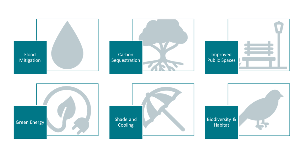
- Newcastle City Council Net Zero Newcastle 2030 – Sets out the scale of the challenge for the city and the areas where we must take action to mitigate and adapt to climate change. Created following widespread consultation, it sets out over 150 ways in which residents, businesses, and organisations can work together to achieve our collective Net Zero future. The plan aims to reduce the impact of extreme rainfall events through climate change, reduce the levels of CO2 around the city, and create greener, more biodiverse spaces across the city.
Notable I4C-related projects and actions:
Blue Green Newcastle
Blue Green Newcastle aims to better protect the whole city centre from multiple sources of flood risk by using innovative, sustainable drainage techniques. The project will help deliver the Council’s wider visions on climate change, carbon reduction, and making the city a more accessible and greener place to live, wor,k and visit.
The approach will be to incorporate blue green infrastructure (BGI) and nature-based solutions (NBS) throughout the city, from the high points at the Town Moor to the River Tyne. A 9000m3 attenuation basin has been completed in June 2025 on the Town Moor to hold water back from the city centre as the pilot phase of Blue Green Newcastle.
Most features will be delivered in public spaces and on the highway, areas with many user groups and a high value to society. There needs to be a broad consideration of the environment and social value across the project to ensure this infrastructure can deliver as much value as possible to the city and those who live, work, or visit. Blue Green Newcastle should be seen as a placemaking project, as potential benefits are far wider than just reducing flood risk and creating a climate-resilient city.
Cost-effective implementation of Blue-Green Infrastructure
The novel optimisation tool developed by Newcastle University is designed to support Newcastle City Council in the strategic, cost-effective implementation of Blue-Green Infrastructure (BGI) within the context of the Blue Green Newcastle project. The tool provides Newcastle City Council with a cost-efficient means to explore a wide range of potential solutions, facilitating the maximisation of the Council’s resources and paving the way towards a more flood-resilient future for the city of Newcastle.
The optimisation tool uses machine learning techniques coupled with a hydrodynamic flood model to enable the automated exploration of potential BGI configurations to find a set of optimal solutions comprising the most efficient strategies for a given capital investment. This represents a departure from traditional practice based wholly on human engineering expertise, which can be a slow and expensive process.
Specifically, the tool works by coupling an evolutionary algorithm with CityCAT, a state-of-the-art, hydrodynamic flood model, to solve a multi-objective optimisation problem. Consequently, decision makers are provided with a set of ‘Pareto-optimal’ solutions, representing the most efficient BGI implementations for a given cost. As shown in Figure 1, which depicts some example solutions, decision makers are presented with a range of solutions for which the trade-offs between flood risk reduction and monetary investment are presented clearly.
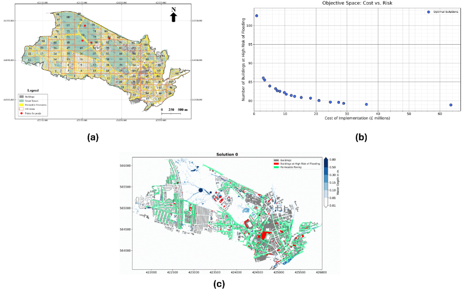
Figure 1: (a) A map showing a catchment around the centre of Newcastle for which the placement of permeable paving and detention basins is being considered. (b) The solutions found by the optimisation tool are plotted within the objective space. (c) One of the solutions from (b) visualised to enable a decision maker to clearly visualise the nature of the proposed solution.
Development of the tool was partially funded under the DAFNI Centre of Excellence for Resilient Infrastructure Analysis within the Building a Secure and Resilient World programme and as such a containerised version of the tool is available on the DAFNI platform.
Stakeholder and community engagement:
As risk management authorities with responsibility for flooding, Newcastle City Council, the Environment Agency, and Northumbrian Water need to play a strategic role in delivering the projects. But key stakeholders, including Newcastle University, who can help identify solutions and locations, assisting in innovation and research, and The Freemen of Newcastle, who have stewardship of the Town Moors and much of the green spaces around the city.
For a project like Blue Green Newcastle to succeed, it must involve a broad range of stakeholders in order that wider benefits can be shared by multiple organisations. Our city is for everyone, and the importance of every space must be valued. The project intends to create betterment across the city, but ensure the solutions are interconnected and enhance the use of spaces. The success of the project starts with those who it impacts becoming part of the journey, people who use or visit the city for any purpose.
But the true success of the project needs landowners, businesses, public organisations, communities, local charities, and the already established groups that represent them all to play their part. Without understanding how spaces in the city are valued by each group, a scheme that considers all cannot be delivered.
Understanding Newcastle’s Climate Challenges
As highlighted above, Newcastle (like many other cities across Europe) faces growing challenges as the climate continues to change. Exactly how much and how quickly these changes are and will occur remains uncertain. Through the I4C project, we are working to give local stakeholders better information about how climate change could affect a region, both now and in the future.
Climate models are powerful tools for exploring possible future climate scenarios, but they also produce huge and complex datasets, with different resolutions, projections, ensemble members, and model domains. As part of I4C, we are working with stakeholders to provide better information on how climatological hazards and corresponding risks are changing, currently a significant barrier that limits the reach of climate science.
As part of I4C, we have two main types of climate models:
- Regional climate models (RCMs): simulate Europe’s climate at a coarse spatial resolution (~12-50 km) and approximate convection (e.g., thunderstorms) using simplified formulas (e.g., EURO-CORDEX).
- Convection-permitting climate models (CPCMs): run at much finer resolutions (~1-4 km), explicitly simulating convection and therefore capturing local storms and heavy rainfall in a more realistic way.
These models provide a rich source of data about our current and future climate, with both broad, efficient coverage (RCMs) and more detailed, local accuracy (CPCMs). Differences in file types, accessibility, data resolution, and reliability all make it challenging to quickly extract useful insights, creating a barrier between climate science and real-world decision-making. To help overcome this, I4C has developed a set of hazard indices which translate complex climate data into clear, practical measures of risk (e.g., intense rainfall, heatwaves, wind, etc). For example, instead of analysing long time series of raw rainfall data, users are provided with a meaningful standardised indicator of rainfall intensity, providing more meaningful indicators of flood risk.
Work at Newcastle University will focus on using observational datasets to better validate climate model outputs for extreme rainfall, one of the biggest climate challenges we face at Newcastle University, due to heavy rainfall rates resulting in surface water flooding (e.g., Summer 2012).
In addition, we are developing an interactive toolkit to make these hazard indices easily accessible, working in collaboration with stakeholders and researchers across Europe through the I4C AdaptaLabs. This tool will feature visual and text-based summaries that allow users to explore climate risks for a specified location, such as
- What is the likelihood of these hazards in the current climate? Today in your selected location of Newcastle upon Tyne, a 50mm rainfall amount is likely to occur over 3 hours __ times. The maximum rainfall rate in 1 hour is expected to be __ mm.
- How is this likely to change in future climate scenarios? In a 3 °C warmer world, (20__-20__), in your selected location of Newcastle upon Tyne, a 50mm rainfall amount is likely to occur over 3 hours __ times. The maximum rainfall rate in 1 hour is expected to be __ mm. This is __ more likely, and __ more intense than current day estimates.
The tool will also show the range of uncertainty between different models, helping users understand the confidence levels behind each projection. This approach, combined with new high-resolution model results from I4C, will make climate data more transparent, accessible, and actionable for everyone.
Contact / Further Information:
- Newcastle University Team:
James McKenna, Christos Iliadis, Amy Green, Hayley Fowler, Vassilis Glenis vassilis.glenis@newcastle.ac.uk - Newcastle City Council Team:
Darren Varley, Carl Hodgson – Blue Green Newcastle Project Manager carl.hodgson@newcastle.gov.uk
www.bluegreennewcastle.co.uk Bluegreen@newcastle.gov.uk